| About Us | Projects | Staff | News | Contact Us | Donate |
|
Clarks River
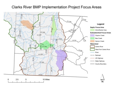
Watershed Based Plan This project used $728,270 grant from the Kentucky Division of Water to implement strategies that will reduce nonpoint source pollution in the Clarks River watershed in Calloway County. The grant includes $436,970 in federal EPA 319(h) funds, and $291,300 in non-federal local match. The project focused on implementing best management practices that addressed the top four pollutants identified during the watershed planning phase, including bacteria, sediment, nutrients, and water temperature. Practices addressed multiple categories of nonpoint source pollution, including agricultural, on-site waste disposal, and urban sources. Projects were focused in four critical areas identified during the watershed planning phase, including a septic focus area around the Almo/Dexter area, the Clayton Creek suwbatershed, the Bee Creek subwatershed, and the Damon Creek subwatershed. A map of the project area has been included below. A total of 84 BMPs were installed through this project. This included the Clarks Rivere Floodplain Improvement project, repair/replacement of 40 failing septic systems, construction of one community lagoon system to accept waste from 40 residences with failing septic systems, and several agricultural practices. The Clarks River Floodplain Improvement project used a floating excavator to remove some major debris and blockages from 15.1 miles of the Clarks River, starting just east of Murray. Debris and blockages were causing flooding and excessive stress on the stream banks, and during flooding events nonpoint source pollutants from the agricultural fields and urban areas surrounding the Clarks River were entering the stream, including nutrients, pesticides and herbicides, bacteria, sediment, and other urban pollutants around Murray. Several different types of agricultural BMPs were installed through this project that addressed sources of nutrient, bacteria, and sediment in the Clarks River watershed, including:
| |||